|
|
|
|
|
 |
|
측량학 - Positioning GPS control points in Korea
|
|
|
 |
측량학 - Positioning GPS control points in Korea
1. Title
Positioning GPS control points in Korea
2. Introduction
한반도 주위를 도는 7~8개의 위성으로부터 받은 GPS정보를 Matlab 프로그램을 통해 계산, PDOP값을 구하여 residual값을 계산, 비교한다. 이를 위해 Taylor series, Least square method 를 사용한다.
3. Materials and Methods
Assuming that the standard deviation is 0.3 m, make a MATLAB
program to calculate receiver position.
1. Choose any one control point
2. Calculate the receiver position epoch by epoch
3. Plot the relative position changes with respect to the time
changes (hour)
4. Overplot the GDOP changes with respect to the time changes
Note:
1) Use the CP positions as initial inputs for iterations
2) Use only the GPS data with elevation angle ] 15°
3) Use only the epoch data with the number of satellites ] 3
4. Results
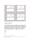
n=8, 상주의 GPS residual 그래프
5. Discussion and Conclusion
.... |
|
|
|
 |
|
|
|
|
|
|
|
|
|
|
|
| |
|
|
|


 2016.05.13
 6페이지
6페이지